img

Advanced Surveying with GIS and Drone Applications

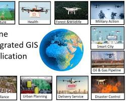
Advanced surveying with GIS and drones has transformed the field by providing a faster, safer, and more accurate way to map the world. Drones capture high-resolution aerial data that is then processed and integrated into GIS, creating intelligent, data-rich maps and 3D models. This powerful synergy enables professionals to analyze a project site comprehensively, streamline planning, and monitor progress in real-time, all while eliminating the risks associated with traditional, ground-based surveying methods.

WinWingz India | Author Level 5

0.0
(0) 0 Students

What you will learn

  • Speed and Efficiency,GIS Integration,

Advanced surveying is the modern practice of measuring and mapping the earth's surface using highly precise technologies. It has evolved significantly from traditional methods with the integration of Geographic Information Systems (GIS) and drones (unmanned aerial vehicles or UAVs). GIS is a powerful system that creates, manages, analyzes, and maps all types of data. In surveying, it is used to organize and visualize spatial data collected from various sources, providing a comprehensive and layered view of a site. Drones are equipped with high-resolution cameras, LiDAR (Light Detection and Ranging) sensors, or other sensors to quickly and accurately capture aerial imagery and 3D data. This combination allows surveyors to collect vast amounts of data more efficiently and safely than ever before, creating highly detailed and accurate maps, digital elevation models, and 3D models of terrain and structures

img
No Discussion Found

0.0

0 Reviews

5
0
4
0
3
0
2
0
1
0
Meet Your Instructor

Trainer
0.0 Rating
18 Students
Author Level 5
104 Courses
About Instructor

Corporate Training

video

₹ 6500.00

  • Course Duration
    5 h 28 m 53 s
  • Course Level
    Medium
  • Student Enrolled
    0
  • Language
    English
This Course Includes
  • 5 h 28 m 53 s Video Lectures
  • 0 Quizzes
  • 0 Assignments
  • 0 Downloadable Resources
  • Full Lifetime Access
  • Certificate of Completion
WinWingz Logo
24/7 Available

Industry-Ready Starts Here With WinWingz

Courses Available

Diverse Courses For Every Ambition

Certification

Win Your Certification & Fly Higher